More than 20 years ago, Dr. Heiko Prümers from the German Archaeological Institute and Prof. Dr. Carla Jaimes Betancourt from the University of Bonn, at that time a student in La Paz, began archaeological excavations on two “mounds” near the village of Casarabe in Bolivia.
The Mojos Plains is a southwestern fringe of the Amazon region. Even though the savannah plain, which flooded several months a year during rainy season, does not encourage permanent settlement, there are still many visible traces of the time before Spanish colonization at the beginning of the 16th century. Next to the “mounds,” these traces include mainly causeways and canals that often lead for kilometers in a dead straight line across the savannahs.
“This indicated a relatively dense settlement in pre-Hispanic times. Our goal was to conduct basic research and trace the settlements and life there,” says Heiko Prümers. In earlier studies, the researchers already found that the Casarabe culture—named after the nearby village—dates to the period between 500 and 1400 AD and, according to current knowledge, extended over a region of around 16,000 square kilometers. The “mounds” turned out to be eroded pyramid stumps and platform buildings.
Initial conventional surveys revealed a terraced core area, a ditch-wall enclosing the site, and canals. In addition, it became apparent that some of these pre-Hispanic settlements were enormous in size. “However, the dense vegetation under which these settlements were located prevented us from seeing the structural details of the monumental mounds and their surroundings,” says Carla Jaimes Betancourt from the Department for the Anthropology of the Americas at the University of Bonn.

LIDAR technology used in the Amazon for the first time
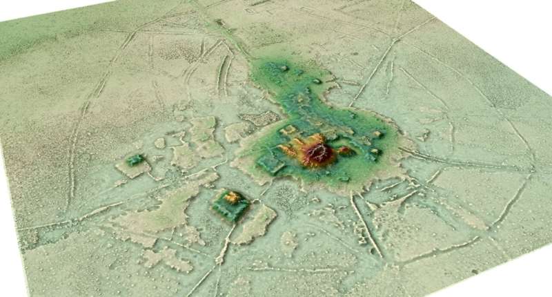
To find out more, the researchers used the airborne laser technology LIDAR (Light Detection and Ranging) for the first time in the Amazon region. This involves surveying the terrain with a laser scanner attached to a helicopter, small aircraft or drone that transmits around 1.5 million laser pulses per second. In a subsequent evaluation step, the vegetation is digitally removed creating a digital model of the earth’s surface, which can also be displayed as a 3D image. “The first results were excellent and showed how effective the technology was even in dense rainforest. From that moment on, the desire arose to map the large settlements of the Casarabe culture using LIDAR technology,” says study leader Dr. Heiko Prümers.
For the current study, in 2019 the team together with Prof. Dr. José Iriarte and Mark Robinson from the University of Exeter, mapped a total of 200 square kilometers of the Casarabe cultural area. The evaluation done by the company ArcTron3 held a surprise. What came to light were two remarkably large sites of 147 hectares and 315 hectares in a dense four-tiered settlement system. “With a north-south extension of 1.5 kilometers and an east-west extension of about one kilometer, the largest site found so far is as large as Bonn was in the 17th century,” says co-author Prof. Dr. Carla Jaimes Betancourt.
#Amazon; #Earlyurbanism; #Hispanic; #LidarTechnology