
#Canada; #ChangingWeatherPatterns; #BritishColumbia; #ForestFires; #GlobalTemperaturesRising
This summer has seen a violent outbreak of forest fires across Canada and North America. According to the Canadian Interagency Forest Fire Center (CIFFC), there were 911 active fires across the country on July 13, nearly 600 of which were characterized as “out-of-control.”
More than half of these active fires are taking place in the provinces of British Columbia, driven by a combination of unusual heat, dry lightning, and drought. The situation is becoming increasingly common thanks to rising global temperatures, diminished rainfall, changing weather patterns, and other related effects of Climate Change.
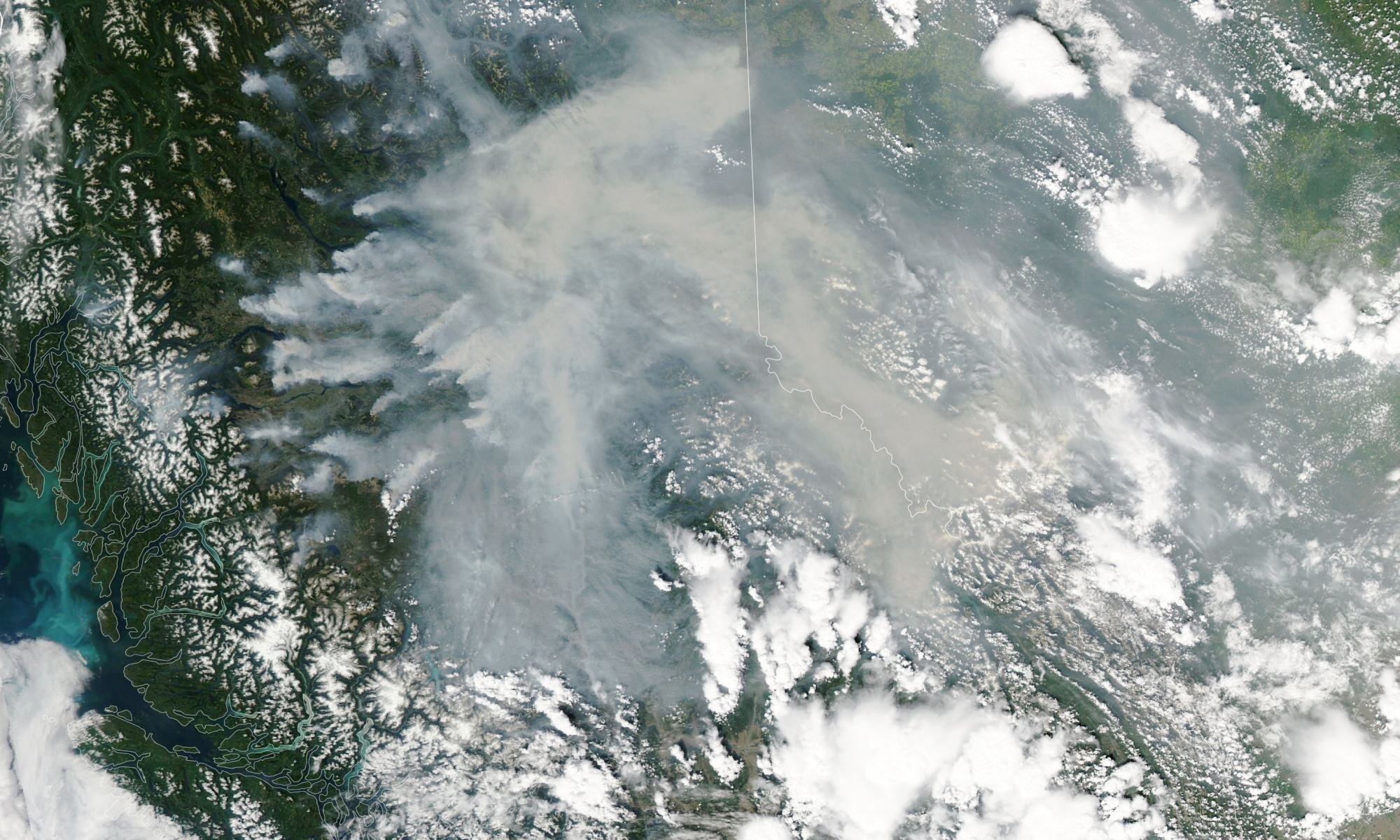
Monitoring forest fires and other meteorological phenomena is an important task for which Earth Observation missions like NASA’s Aqua satellite were created. On July 12, with six weeks left in the Canadian fire season, Aqua captured images of some of the largest fires over British Columbia using its Moderate Resolution Imaging Spectroradiometer (MODIS) instrument.
The image above shows some of the biggest “hot spots” in the province, which produced dense plumes of smoke blowing eastward through the Rocky Mountains and into Alberta and the Northwest Territories.
The Aqua and Terra satellite work in tandem to acquire data twice daily at mid-latitudes using their MODIS instruments. These four daily observations inform operational fire management while advancing global monitoring of wildfires and their effects on the local environment, the planet’s atmosphere, and climate.
In addition, these fires produce massive plumes of smoke that reach the upper atmosphere, where high-level winds spread the smoke and particulate matter to neighboring areas. Several of these fires have produced smoke-infused storm clouds in recent weeks, known as pyrocumulonimbus (pyroCb).

“We observed 14 pyroCbs with satellites on July 9-10 alone—several in British Columbia and some in Quebec,” said David Peterson, an atmospheric scientist with the U.S. Naval Research Laboratory. “This surge in activity has made 2023 the most active year for pyroCbs both in Canada and worldwide since we began tracking their numbers closely about a decade ago.”
As of July 13, Peterson and colleagues observed 90 pyroCbs in Canada and 104 worldwide. This set a new record for Canada and the world, the previous of which were set in 2021 (50 and 100, respectively), and prompted Environment Canada to issue air quality warnings for communities throughout British Columbia, Alberta, and the Northwest Territories.
In addition, more than 1.2 million hectares were damaged by fire in British Columbia as of July 12, 2023, roughly 30 times the average by this point in the year.
A major outbreak in June struck the eastern province of Quebec and led to air quality issues in neighboring Ontario and parts of Minnesota, Wisconsin, Illinois, and Michigan. This year’s totals represent 13% of the 9.4 million hectares that burned nationwide as of July 12. It’s also an almost 25% increase over the 7.1 million hectares that burned in 1997, the second-highest year recorded by the CIFFC. Monitoring and tracking these firestorms is vital to mitigation and adaptation efforts as average global temperatures continue to rise.