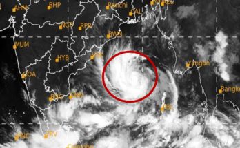

IBNS-CMEDIA: Cyclone Arnab completed its landfall along the Andhra Pradesh coast early on Wednesday after a process lasting more than six hours, bringing heavy rain and strong winds to parts of Andhra Pradesh and Odisha.
The storm crossed the coast as a very severe cyclonic storm before weakening into a severe cyclonic storm, according to the India Meteorological Department (IMD).
More than 1.8 lakh people were evacuated ahead of its arrival as authorities monitored rainfall, power disruptions and damage caused by uprooted trees.
In a bulletin issued at 9.50 am, the IMD said the cyclone’s centre had moved completely over land.
 Photo: Screen grab from X
The system was located over the Andhra Pradesh and Yanam coasts, around 20 km east of Narsapur, 40 km south-south-west of Yanam, 60 km south-south-west of Kakinada and 90 km east-north-east of Machilipatnam.
“The latest observations indicate that the landfall process has been completed with the central region moving completely into land,” the IMD said.
The weather department said the cyclone crossed the Andhra Pradesh and Yanam coasts as a very severe cyclonic storm, with maximum sustained wind speeds of 125–135 kmph and gusts reaching 150 kmph.
It weakened into a severe cyclonic storm at 8.30 am.
🚨 CYCLONE ARNAB: SEVERE FLOODING AND DESTRUCTION! 🌪️ Powerful winds and rising floodwaters are wreaking havoc, threatening lives, homes, and livelihoods. The unfolding situation highlights the urgent need for disaster preparedness and public safety. #CycloneArnab #ExtremeWeather
— Noor Shehzad (@NoorShehzaddd) October 28, 2026
Over 1.8 lakh people evacuated
Cyclone Arnab brought heavy rainfall to several districts in Andhra Pradesh and Odisha, prompting authorities to evacuate more than 1.8 lakh people from vulnerable areas ahead of its arrival.
Andhra Pradesh recorded particularly heavy rainfall in several districts. Visakhapatnam received 315 mm of rain by 8.30 am, the highest among the locations listed in the report.
Vizianagaram followed with 301 mm, while Anakapalli recorded 275 mm. Srikakulam received 257 mm, and Krishna district recorded 223 mm.
 Photo: Screen grab from X
In Odisha, Koraput recorded 188 mm of rainfall, followed by Ganjam with 161 mm and Gajapati with 135 mm.
Despite the heavy rain and strong winds, officials had reported no loss of life in either state at the time of the update.
However, power supplies were disrupted, and trees were uprooted in affected areas. Authorities also closed some schools and cancelled certain train services as the storm moved inland.
Heavy rainfall was expected to continue on Wednesday and Thursday as the cyclone’s effects persisted, according to the supplied report.
चक्रवाती तूफान ‘अर्नब’ ने विशाखापत्तनम के पास लैंडफॉल करना शुरू कर दिया है। 📷 #CycloneArnab #Cyclone #CycloneAlert #SevereWinds #WeatherAlert #IMD #BreakingNews #IndiaNews #India24LiveNewsCyclone Arnab Cyclone Arnab Cyclone Update 150 kmph wind Cyclone Alert India https://t.co/uVtDsuKzh2
— The News Brunch (@thenewsbrunch) October 28, 2026
Flights cancelled as storm disrupts travel
Airlines cancelled flights to Visakhapatnam and Vijayawada on Wednesday as a precautionary measure amid adverse weather conditions.
The disruption followed extensive preparations by authorities in Andhra Pradesh and Odisha, where emergency teams had been placed on standby, and people moved from areas considered vulnerable to flooding and strong winds.
The storm’s passage also affected railway operations, with some train services cancelled.
Authorities continued monitoring conditions as heavy rain and wind-related damage disrupted normal activities in parts of the two states.
 Photo: Screen grab from X
How cyclone Arnab got its name
Bangladesh proposed the name Arnab, which features on the official list of tropical cyclone names adopted in 2020 by the World Meteorological Organisation (WMO) and the United Nations Economic and Social Commission for Asia and the Pacific (UNESCAP) Panel on Tropical Cyclones.
The name is commonly associated with the Bengali word for the ocean or sea.
The regional naming system includes contributions from 13 countries: Bangladesh, India, Iran, the Maldives, Myanmar, Oman, Pakistan, Qatar, Saudi Arabia, Sri Lanka, Thailand, the United Arab Emirates and Yemen.
Cyclone Arnab continues its landfall process along the Andhra Pradesh coast, bringing severe cyclonic storm conditions, heavy rainfall, and strong winds, prompting rescue operations. Cyclone remains ‘practically stationary’ along Andhra coast. #AndhraPradesh #CycloneArnabUpdate https://t.co/oYwLqio1py
— Lokmat Times Nagpur (@LokmatTimes_ngp) October 28, 2026
Each country submitted 13 names, taking the total to 169. Meteorological authorities use the names in sequence as tropical cyclones develop over the North Indian Ocean, which covers the Bay of Bengal and the Arabian Sea.
Naming individual cyclones helps authorities, the media and the public identify specific weather systems and follow their development.
It also reduces confusion when multiple storms occur in the region.