A solar storm like the one that caused a nine-hour blackout across Quebec in 1989 could have even more dramatic effects if it struck the eastern United States today. Now, scientists have developed new tools to detect these storms before they strike by mapping the hidden electrical structure beneath our feet, revealing how the ground itself could influence the impact on our power grid.
Mapping Earth’s hidden electrical underworld
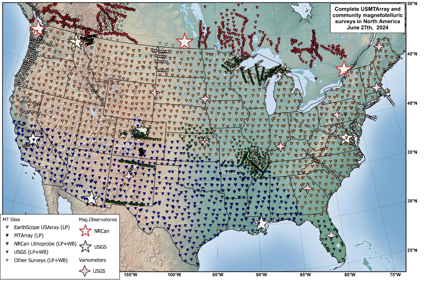
After 18 years of work and measurements at over 1,800 locations across the country, the United States Magnetotelluric Array (USMTArray) has completed the first comprehensive survey of electrical properties beneath the continent. In the new study, scientists from the Center for Astrophysics | Harvard & Smithsonian (CfA) present a three-dimensional map tracing how electrical currents flow through underground rocks, fluids, and ancient geological formations, uncovering hidden pathways and structures that shape North America from below.
The USMTArray captures natural changes in Earth’s electric and magnetic fields at the surface. Since mineral composition, fluids, and temperatures all affect how electricity moves underground, these measurements allow scientists to peer beneath the surface: from shallow layers of sediment to the deep, ancient roots that have anchored the North American continent for over a billion years.
“Magnetotelluric data, which measures natural electric and magnetic field variations on the Earth’s surface to map subsurface electrical resistivity, responds very strongly to things like fluids and melt,” said Anna Kelbert, an Earth Science Project Scientist at the CfA and the lead author of the new paper published in Reviews of Geophysics.
Kelbert added that USMTArray also provides a 3D picture of electrical resistivity from Earth’s surface to its mantle. “That gives us a fundamentally different window into Earth compared to seismic data.”
Solar storms and power grid risks
These discoveries have important real-world consequences. When geomagnetic storms strike, energy from the sun can set off electrical currents that travel through the ground and into our power lines. The 1989 blackout in Quebec, Canada, stands as a vivid reminder: During that event, storm-driven geoelectric fields overwhelmed the Hydro-Québec power grid, leaving millions without electricity.
According to Kelbert and her team, during that same storm, geoelectric field amplitudes at a site in Maine reached 22.79 volts per kilometer. At that strength, the ground itself was conducting electricity at levels far beyond what power infrastructure is built to handle. This poses a serious risk for power grids, which are designed to handle alternating current, not direct current.
The Northern Lights, also known as the Aurora Borealis, are more active when there are solar flares on Earth’s sun, or when an intense coronal mass ejection forces plasma from the sun into space. That same ejection can cause geomagnetic storms on Earth, which can in turn cause damage to Earth’s electrical grid. Scientists from the USMTArray project have collected data over nearly 20 years to develop new tools that can predict where and when these storms will strike. Credit: U.S. Geological Survey
“I believe that anything above 1 V/km is considered a threat by the power grid industry,” Kelbert said. “For anything like 20 V/km, if the geoelectric field of that amplitude was oriented along a typical 200-km power line in Maine, we’d be looking at voltages of 4,000 V, which would be driving a strong quasi-DC current across that line.”
If a strong, sustained surge of direct current flows through the system, it can overload transformers, leading to overheating and even destroying equipment that is costly and time-consuming to replace. A widespread failure like the one in 1989, but on a larger scale, could result in a prolonged outage affecting much of the nation.
From crude models to real-time mapping
The USMTArray brings a new level of precision to our ability to warn about these hazards, Kelbert noted. Previously, scientists had to rely on simplified, one-dimensional models of how electricity moves through the ground, but the real geology beneath the United States is far more complex. The new data reveal that geoelectric hazards can vary dramatically, even between locations just a few miles apart, with risk levels that can differ as much as those between locations hundreds of miles away.
Today, data from the USMTArray feeds into a real-time risk map, managed by the National Oceanic and Atmospheric Administration (NOAA) and the United States Geological Survey (USGS), that monitors electric fields across the country as storms unfold. This allows scientists and officials to estimate electric risk at specific locations, providing a much clearer, more detailed picture of potential dangers than ever before.
Revealing North America’s deep past
Launched in 2006, the project set out to create a detailed image of North America’s deep structure. The resulting three-dimensional electrical model traces the paths of landmasses that once collided, maps the continent’s stable cores that have persisted for billions of years, and reveals how North America took shape. Unlike seismic methods, these electrical measurements can detect features such as ancient subduction zones, which are geologically inactive, marked by conductive materials like graphite and sulfide minerals, hidden deep underground.
Because this map reveals both underground fluids and minerals that are good conductors of electricity, it could also become a valuable tool for finding important resources, including mineral deposits and underground sources of heat.
“There is still a gap between knowing the geoelectric fields in real-time and using this information to make timely operational decisions,” Kelbert said. “Prediction, not just detection, is the next frontier.”
Provided by Harvard-Smithsonian Center for Astrophysics