
Hurricane Beryl poses a major threat to communities in the Caribbean Sea after intensifying at an explosive rate. It is the earliest Category 5 Atlantic hurricane on record.
It sets an alarming precedent for what is expected to be a very active hurricane season with risks for the entire basin and once again highlights the need for multi-hazard early warnings.
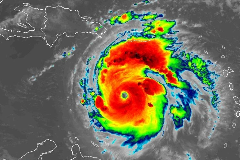
Beryl weakened from the top-ranked Category 5 to Category 4 status on the Saffir Simpson scale, remaining very dangerous as it heads towards Jamaica. Maximum sustained winds are near 145 mph (230 km/h) with higher gusts and extend outward up to 45 miles (75 km), according to WMO’s Regional Specialized Meteorological Centre Miami, which is operated by the US National Hurricane Center (NHC).
Beryl is forecast to be at major hurricane intensity while it passes near Jamaica later on 3 July and the Cayman Islands. Additional weakening is expected thereafter, though Beryl is forecast to remain a hurricane in the northwestern Caribbean, said NHC. A Hurricane Watch is in effect for the south coast of Haiti and part of the East coast of Mexico’s Yucatan Peninsula – meaning that hurricane conditions are possible within 48 hours.
WMO is providing regular updates and meteorological advice to the UN and humanitarian system through its WMO Coordination Mechanism, supported by the Federal Office of Meteorology and Climatology MeteoSwiss – Weather4UN Pilot Project, German Weather Service DWD and GeoSphere Austria.
Beryl hit the southern Windward Islands at Category 4 strength on the Saffir Simpson scale on 1 July. It made a direct hit on Grenada and had major impacts on St Vincent and Grenadines. These are small islands with little experience in coping with a category 4 hurricane.
NHC is warning that storm surge will increase water levels by 6 -9 feet (1.9 – 2.7 meters) above normal tide levels in Jamaica, with rainfall totals of 4 – 8 inches (101 – 202 mm) and locally up to 12 inches (303 mm). This rainfall may cause flash flooding in vulnerable areas, including in parts of Haiti.
“It takes just one landfalling hurricane to set back years of socio-economic development. For example, Hurricane Maria in 2017 cost Dominica 800% of its Gross Domestic Product. Early warnings by the WMO community and improved disaster risk management have dramatically reduced fatalities, but Small Island Developing States in the Caribbean still suffer disproportionately,” said WMO Deputy Secretary-General Ko Barrett.
“This is why WMO and its partners have prioritized early warning action in small islands under the international Early Warnings For All initiative,” said Ko Barrett, who coordinates WMO’s contribution to the UN Secretary-General’s initiative.
“We need to be especially vigilant this year due to near-record ocean heat in the region where Atlantic hurricanes form and the shift to La Niña conditions, which together create the conditions for increased storm formulation,” said Ko Barrett.

Tropical-Storm-Force Wind Speed Probabilities – July 2024NOAA
Rapid intensification
The Intergovernmental Panel on Climate Change predicts that the proportion of intense tropical cyclones and average and maximum precipitation rates will increase as a result of climate change.
Sea level rise, worsened by storm surge, increases the potential risk for coastal communities.
Hurricane Beryl intensified from a tropical depression to a major hurricane in 42 hours.. This is unprecedented for June but is in line with the recent trend towards very rapid intensification – as was the case with Hurricane Otis which grew to a Category 5 hurricane overnight and hit the Mexican resort of Acapulco last October.
One reason why Hurricane Beryl intensified to a Category 5 hurricane more than two weeks earlier than any other Atlantic hurricane on record is due to extremely high ocean heat content levels. Caribbean ocean heat content today is normally what we get in the middle of September, according to Philip Klotzbach, who is part of WMO’s expert network of scientists.
Sea surface temperatures in this region have been record high for the respective month for 14 months (figures until May 2024).
The central and eastern Atlantic traditionally become more active in August, in part because ocean temperatures have had time to warm and fuel developing systems. Normally, ocean temperatures aren’t warm enough in June and July to help tropical systems thrive.
It sets the stage for what is expected to be an especially active and dangerous hurricane season for the entire basin – Atlantic, Caribbean and Central America.

Hurricane Beryl Total Rainfall – July 2024NOAA
Active season
NOAA’s Climate Prediction Center forecasts a range of 17 to 25 named storms (average is 14). Of those, 8 to 13 are forecast to become hurricanes (average is 7), including 4 to 7 major hurricanes (average is 3). A major hurricane is category 3, 4 or 5 on the Saffir Simpson, with winds of 178 kmh/111 mph or higher.
The Atlantic hurricane season lasts from 1 June to 30 November and is carefully monitored by the World Meteorological Organization Tropical Cyclone Programme. There have now been eight consecutive years of above average activity. The last below normal season was in 2015.
Warm sea surface temperatures and a lack of wind shear due to the transition from El Niño season to La Niña are fuel for tropical development.